





Navigation Without a Phone: Backup Skills Worth Knowing

Phone navigation has made backcountry travel easier for almost everyone. It has also made it easier to be helpless when the phone dies, gets wet, or loses signal in a valley. The answer is not to abandon the phone. It is to carry a backup that does not depend on a battery, and to practice it enough that it works when you need it.
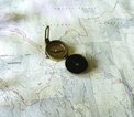
The most reliable backup is a paper map and a compass, used together. A map alone tells you where things are. A compass alone tells you which way is north. Together they let you figure out where you are and where you are going, even in fog or dense trees where landmarks disappear.
Orient the Map and Take a Bearing
The basic skill is orienting the map. Lay it flat, place the compass on the map, and rotate the map until the compass needle lines up with the north lines printed on the map. Now the map matches the ground. From there, you can identify features around you — a ridge, a stream, a trail junction — and match them to the map.
Taking a bearing is the next step. Point the compass at a landmark you can see, note the direction, and then find that direction on the map. If you want to travel toward a specific point, set the bearing on the compass and follow it, checking as you go. This is called navigating on a bearing, and it is how people move through terrain with no visible trail.
Pacing and timing are simple additions. If you know roughly how long it takes you to walk a mile on flat ground and on a climb, you can estimate distance traveled. Counting steps works too, though it takes practice. These estimates are not precise, but they keep you from overshooting a turn by a mile.
Terrain association is the most useful skill of all. Instead of measuring, you match what you see to what the map shows: a saddle here, a creek bend there, a cliff on the left. With practice, you can follow a route by reading the land itself.
Practice Before You Need It
None of this works if you only try it in an emergency. Practice on familiar trails first. Leave the phone in your pocket and navigate with the map. Make mistakes where the consequences are small. Learn how your compass behaves near metal objects, and how declination — the difference between magnetic north and true north — affects your bearings in your area.
Carry a real compass, not a toy. A baseplate compass with a clear body and adjustable declination is the standard for a reason. Keep the map in a waterproof case and know where it is without looking.
The goal is not to distrust your phone. It is to have a second way of knowing where you are. Redundancy is what turns a minor problem into a non-event. A dead battery should be an inconvenience, not an emergency.






Phones die, batteries drain, and signal disappears — here is how to stay found without one.
A practical walkthrough of the base, mid, and shell system that keeps you warm on the ascent and dry on the summit.
Trekking poles are not automatic equipment. Here is how to decide if they earn their place on your next trip.
Contour lines, scale, and terrain association explained for hikers who rely on their phone a little too much.
From cowboy coffee to a lightweight press, here is how to get a decent cup at camp without hauling a kitchen.